Glider Map Switzerland 1:350,000
In Switzerland, the Federal Office of Civil Aviation (FOCA) is responsible for the preparation of the aeronautical chart of Switzerland with specific air traffic control information for gliders. FOCA delegates this task to Skyguide, which develops the aviation-specific content, and to swisstopo, which is responsible for the background map, the integration of the aviation-specific content and the distribution of the product.
Edition 2026: valid from 19 March 2026
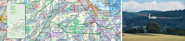
The aeronautical chart for Switzerland with air traffic control information especially for glider pilots.
This general map includes airports and airfields, classified air space, restricted and hazardous areas as well as other useful information for glider pilots. The map is printed double-sided . Front: western part, back: eastern part. The map is revised annually by skyguide and swisstopo.
Editors: skyguide, 8602 Wangen bei Dübendorf and the Federal Office of Topography, swisstopo.
A digital version of the Glider Chart is also available: Digital Glider Map
Further information
Prices for publishing products (available in German and French).
(PDF, 2 Pages, ~65 Ko, EN)New and updated maps of the last 3 months.
(PDF, 1 Page, ~63 Ko, EN)Status of Updates of swisstopo maps.
(PDF, 2 Pages, ~84 Ko, EN)1 product
- ISBN: 978-3-302-06014-9
- Edition: 2026
- State of updates: 2026
-
Description:
The aeronautical chart for Switzerland with air traffic control information especially for glider pilots. This general map includes airports and airfields, classified air space, restricted and hazardous areas as well as other useful information for glider pilots. The map is printed double-sided . Front: western part, back: eastern part. The map is revised annually by skyguide and swisstopo. Editors: skyguide, 8602 Wangen bei Dübendorf and the Federal Office of Topography, swisstopo. A digital version of the Glider Chart is also available: Digital Glider Map
"" added to basket
Go to the basket