Aeronautical Chart ICAO Switzerland 1:500000
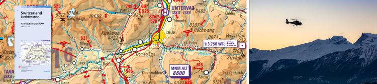
The official Aeronautical Chart ICAO Maps of Switzerland at a scale of 1:500,000 includes airports, aerodromes, airspaces, restricted and danger zones as well as air traffic control informaton for Switzerland and the neighbouring countries. In Switzerland, the Federal Office of Civil Aviation (FOCA) is responsible for the preparation of the aviation maps. FOCA delegates this task to Skyguide, which develops the aviation-specific content, and to swisstopo, which is responsible for the background map, the integration of the aviation-specific content and the distribution of the product.
Edition 2026: valid from 19 March 2026
The official aeronautical map of Switzerland in 1:500,000 scale is updated annually by skyguide and published by swisstopo as prescribed in the regulations of the international aeronautical conventions. The terminal areas (TMAs) of the airports of Geneva, Zurich, Basel, Bern, Grenchen and St. Gallen-Altenrhein are covered with a more detailed map in 1:250,000 scale. Both maps are available separately or together in one set.
Further information
Prices for publishing products (available in German and French).
(PDF, 2 Pages, ~65 Ko, EN)New and updated maps of the last 3 months.
(PDF, 1 Page, ~63 Ko, EN)Status of Updates of swisstopo maps.
(PDF, 2 Pages, ~84 Ko, EN)3 products
- ISBN: 978-3-302-06012-5
- Edition: 2026
- State of updates: 2026
-
Description:
The official aeronautical map of Switzerland is updated annually by skyguide and published by swisstopo as prescribed in the regulations of the international aeronautical convention. The map includes airports and airfields, classified air space, restricted and hazardous areas as well as air traffic control information for Switzerland and the adjoining foreign territories. Further information about air space in Switzerland, airport radio frequencies and other useful information for pilots is included in this product. Editors: skyguide, 8602 Wangen bei Dübendorf and the Federal Office of Topography, swisstopo. A digital version of the Aeronautical Chart ICAO 1:500 000 is also available. Digital Aeronautical Chart ICAO 1:500 000

- ISBN: 978-3-302-06015-6
- Edition: 2026
- State of updates: 2026
-
Description:
Area Chart ICAO 1:250 000, Edition 1, as of 11 March 2010 Airspace covered: GND - FL 195 This map is a new product on a scale of 1:250 000 and is printed on both sides. The front side of the Zurich Area" map covers the terminal areas (TMAs) of the airports of Zurich (LSZH), Basel (LFSB), Bern (LSZB), Grenchen (LSZG) and St. Gallen-Altenrhein (LSZR). On the back is the "Geneva Area" with the TMAs of the Geneva Airport (LSGG) illustrated in large scale. A basic map, now revised and specially adapted to the needs of VFR pilots, provides the topographic basics. Combined with the new, more readable depiction of flight safety information, the new map simplifies orientation in the complex airspaces of the airports listed. A table with important frequencies for Switzerland and adjoining border areas was also added. The new map is an ideal supplement to the official aviation map of Switzerland ICAO 1:500 000. It is updated yearly so it is always current."

- ISBN: 978-3-302-06016-3
- Edition: 2026
- State of updates: 2026
-
Description:
2 sheets (Aeronautical Chart ICAO and AREA Chart ZH /GE) in a practical protective case.
"" added to basket
Go to the basket