Cartes géologiques spéciales
Diverses cartes géologiques et tectoniques aux échelles entre 1:25 000 et 1:100 000 complètent l'Atlas géologique de la Suisse au 1:25 000 et les GéoCartes au 1:500 000.
Carte papier
Les cartes géologiques spéciales existent dans des échelles comprises entre le 1:25 000 et le 1:100 000 et complètent l’Atlas géologique de la Suisse au 1:25 000 et les GéoCartes au 1:500 000. Leur délimitation a été choisie dans une perspective géographique ou thématique; elles renseignent sur les conditions géologiques régionales et mettent en lumière des priorités thématiques choisies.
Informations Complémentaires
Rechercher dans la liste :
14 produits

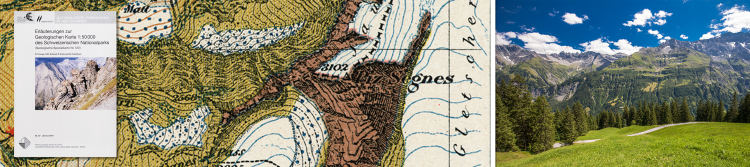
- Auteur: G. Frischknecht, H. Jenny & J. Kopp
-
Description:
G. Frischknecht, H. Jenny & J. Kopp: Geologische Karte der Adula, 1:50000, 1923 (Vierfarben-Reproduktion 1998, auf Spezialpapier). - Erläuterungen vergriffen.

- Auteur: H. Preiswerk, L. Bossard, O. Grütter, P. Niggli, E. Kündig & E. Ambühl
-
Description:
H. Preiswerk, L. Bossard, O. Grütter, P. Niggli, E. Kündig & E. Ambühl: Geologische Karte der Tessineralpen zwischen Maggia- und Blenio-Tal / Carta geologica delle Alpi ticinesi fra Valle Maggia e Val Blenio, 1:50000 (Legende deutsch und italienisch), 193

- Auteur: J. Oberholzer † (Bearb.)
-
Description:
J. Oberholzer † (Bearb.): Geologische Karte des Kantons Glarus, 1:50000, 1942 (Vierfarben-Reproduktion 1984, auf Syntosil). - Ohne Erläuterungen.

- Auteur: A. Isler, F. Pasquier & M. Huber (Bearb.)
-
Description:
A. Isler, F. Pasquier & M. Huber (Bearb.): Geologische Karte der zentralen Nordschweiz, 1:100000 (mit angrenzenden Gebieten von Baden-Württemberg). Herausgegeben gemeinsam mit der NAGRA, 1984.

- Auteur: W. H. Müller, M. Huber, A. Isler & P. Kleboth
-
Description:
Erläuterungen zur geologischen Karte der zentralen Nordschweiz (Spezialkarte Nr. 121), von W. H. Müller, M. Huber, A. Isler & P. Kleboth, 1984.

- Auteur: R. Dössegger (Bearb.)
-
Description:
R. Dössegger (Bearb.): Geologische Karte des Schweizerischen Nationalparks, 1:50000. Herausgegeben gemeinsam mit der Kommission für wissenschaftliche Erforschung des Nationalparks, 1987.

- Auteur: R. Trümpy, S. M. Schmid, P. Conti & N. Froitzheim
-
Description:
Erläuterungen zur geologische Karte des Schweizerischen Nationalparks (Spezialkarte Nr. 122), von R. Trümpy, S. M. Schmid, P. Conti & N. Froitzheim, 1997, ISBN 3-906723-12-7.

- Auteur: A. Steck, B. Bigioggero, G. V. Dal Piaz, A. Escher, G. Martinotti, H. Masson
-
Description:
A. Steck, B. Bigioggero, G. V. Dal Piaz, A. Escher, G. Martinotti, H. Masson (1999): Carte tectonique des Alpes de Suisse occidentale et des régions avoisinantes, 1:100000, ISBN 3-906723-15-1. Notice explicative par Albrecht Steck, Jean-Luc Epard, Arthur Escher, Yves Gouffon et Henri Masson (2001).

- Auteur: M. Donzeau, R. Wernli, J. Charollais & G. Monjuvent
-
Description:
M. Donzeau, R. Wernli, J. Charollais & G. Monjuvent: Saint-Julien-en-Genevois, 1:50000. Publiée avec le Bureau de Recherches Géologiques et Minières, 1997, ISBN 3-906723-17-8. - Notice explicative par M. Donzeau, R. Wernli, J. Charollais & G. Monjuvent, 1

- Auteur: Y. Kerrien, C. Turrel, G. Monjuvent, J. Charollais, A. Lombard, F. Balmer, F. Olmari, R. Papillon, L. Fontannaz, G. Amberger, C. Ruchat, Y. Grebert & M. Marthaler
-
Description:
Y. Kerrien, C. Turrel, G. Monjuvent, J. Charollais, A. Lombard, F. Balmer, F. Olmari, R. Papillon, L. Fontannaz, G. Amberger, C. Ruchat, Y. Grebert & M. Marthaler: Annemasse, 1:50000. Publiée avec le Bureau de Recherches Géologiques et Minières, 1998, ISB

- Auteur: R. Plancherel, C. Caron & P. Broquet
-
Description:
R. Plancherel, C. Caron & P. Broquet: Samoëns - Pas-de-Morgins, 1:50000. Publiée avec le Bureau de Recherches Géologiques et Minières, 1998, ISBN 3-906723-26-7. - Notice explicative par R. Plancherel, 1998, ISBN 3-906723-27-5.

- Auteur: A. Berger and I. Mercolli
- ISBN: 978-3-302-40016-7
-
Description:
A. Berger and I. Mercolli (2006): Tectonic and Petrographic Map of the Central Lepontine Alps, 1:100 000 (disponible aussi plano), ISBN 978-3-302-40008-2.- Explanatory notes by A. Berger, I. Mercolli and M. Engi, 2007, ISBN 978-3-302-40016-7.

- Auteur: O. A. Pfiffner, M. Burkhard, R. Hänni, A. Kammer, R. Klligflied, N. S. Mancktelow, J. W. Menkveld, J. G. Ramsay, S. M. Schmid & R. Zurbriggen
- ISBN: 978-3-302-40042-6
-
Description:
O. A . Pfiffner and al.: Structural Map of the Helvetic Zone of the Swiss Alps, including Vorarlberg (Austria) and Haute Savoie (France), 1:100000, 7 sheets.- Explanatory notes by O. A. Pfiffner. ISBN 978-3-302-40042-6

- Auteur: A. Berger, I. Mercolli, M. Herwegh and E. Gnos
- ISBN: 978-3-302-40093-8
- Edition: 2017
-
Description:
Geological Map of the Aar Massif, Tavetsch and Gotthard Nappes, 1:100 000. - Explanatory notes by A. Berger, I. Mercolli, M. Herwegh and E. Gnos.
"" ajouté au panier
Aller au panier