GeoMaps 1:500,000
A range of six small scale geological, tectonic, hydrogeological, geophysical and paleoglaciological maps of Switzerland. These maps give a broad overview of the composition and major features of the underlying structure of our country.
Printed maps
- The Geological Map of Switzerland 1:500,000 provides an overview of the distribution of the uppermost rock strata occurring in Switzerland. Additionally, age and simplified tectonic assignment of the different types of rocks are given.
- The Tectonic Map of Switzerland 1:500,000 displays the large-scale structural and tectonic units, which contribute to a better understanding of the geological buildup of the Alps.
- The Hydrogeological Maps of Switzerland – Groundwater resources 1:500,000 shows the various groundwater resources in Switzerland and provides productivity information.
- The Hydrogeological Maps of Switzerland – Vulnerability of Groundwater Resources 1:500,000 indicates the vulnerability of groundwater resources to possible contamination.
- The Gravimetric Map of Switzerland – Bouguer Anomalies 1:500,000 shows on the one hand the regional negative anomalies associated with the Alps and on the other hand the positive anomaly of the Sesia–Finero zone, which signifies an excess of mass at depth.
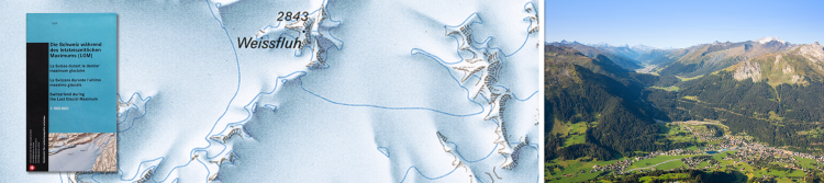
- The map of “Switzerland during the Last Glacial Maximum (LGM), 1:500,000” shows the maximum extent of glaciation in Switzerland at the height of the last Ice Age about 24,000 years ago.
Further information
Search in the list:
6 products

- ISBN: 978-3-302-40125-6
- Edition: 2024
-
Description:
Tectonic Map of Switzerland 1: 500 000. – Explanatory notes by D. Bernoulli, S. Dall’Agnolo, R. Fantoni, Y. Gouffon, P. Jordan, H. Madritsch, J. Mosar, O. A. Pfiffner, V. Picotti, F. L. Schenker, F. Schlunegger, S. M. Schmid, 2024.

- Author: A. Bini, J.-F. Buoncristiani, S. Couterrand, D. Ellwanger, M. Felber, D. Florineth, H. R. Graf, O. Keller, M. Kelly, C. Schlüchter, & P. Schoeneich
- ISBN: 978-3-302-40049-5
- Edition: 2009
-
Description:
Switzerland during the Last Glacial Maximum (LGM), 1:500 000, 2009.

- ISBN: 978-3-302-40036-5
- Edition: 2008
-
Description:
Gravimetric Map of Switzerland 1:500 000 - Bouguer Anomalies, 2008. Compiled by: Geophysical Institut (University of Lausanne) for the Swiss Geophysical Commission. Redaction : R. Olivier, B. Dumont and E. Klingelé

- Author: R. Philipp, F. Flury, M. George, T. Kempf, R. Kozel, V. Lützenkirchen, F. Matousek, M. Sinreich, P. Tissières, J.-P. Tripet
- ISBN: 978-3-302-40037-2
- Edition: 2008
-
Description:
Hydrogeological Map of Switzerland 1:500 000 - Vulnerability of Groundwater Resources, 2008. The sheet is originally published as Table 8.7 of the Hydrological Atlas of Switzerland HADES (FOEN, 2004 and 2007).

- Author: T. Bitterli, P. Avoilat, R. Brändli, R. Christe, Fracheboud, D. Frey, M. George, F. Matousek, J.-P. Tripet
- ISBN: 978-3-302-40024-2
- Edition: 2007
-
Description:
Hydrogeological Map of Switzerland 1:500 000 - Groundwater Resources, 2008. The sheet is originally published as Table 8.6 of the Hydrological Atlas of Switzerland HADES (FOEN, 2004 and 2007).

- ISBN: 3-906723-39-9
- Edition: 2005
-
Description:
Geological Map of Switzerland 1:500 000, 2005. Compiled by: Geological Institute, University of Bern, and Federal Office for Water und Geology.
"" added to basket
Go to the basket